PROGRAM
Day 1 - arrival at Denver airport
We will arrive at Denver airport in the late afternoon. If storms are very closeby we will quickly get out and start our storm chase immediately. Otherwise, we will go for dinner and your guide will brief you on the potential for severe weater for tomorrow and the days beyond.
The next 10 days you will be driving across the central part of the USA, not knowing where you will be at night. We will go where the weather is. One thing is for sure, we will not cross the border into Mexico, but we might chase in Canada if needed, as we have done before.
Day 2 Storm chase day
Every day is different. If there's a chance of severe weather with the potential for supercells and tornadoes, we will drive out. Normally that would mean that we have to cover 300-500 miles (500-800 km) just to get to the right spot. However, sometimes we're lucky and can stay put or drive for an hour or so.
Typical day
07 AM: Wake up
08 AM: Weather briefing and decision what time to leave the hotel and what is the first target area
01-04 PM: arrival in target area
03-05 PM: maneuvering in the area to get to the best place.
04-06 PM: Start of the chase
05-09 PM: Chasing storms and tornadoes
10 PM: Weather briefing for tomorrow. Potentially driving 1-2 hours to be at a better position
Motherships
There's alot of slang in Storm Chasing. There;s even different slang words in different chase communicties. The mothership is used frequently to describe the spectacular cloud formations that often happen with supercells. Turkies are small columns of clouds shooting up in the air (towering cumulus).
Rear Flank Downdraft (RFD)
17 May - 2018 - South Dakota
A supercell can be recognized by identifying the RFD. That's a dark threatening horizontal band of clouds that spirals inward to the center of the storm. It's the boundary between cool air associated with the evaporation of raindrops near the rear of the storm and the warm and humid air the flows into the storm. RFD winds can be destructive and will normally be from the west, while inflow will be from the south, south-east or east. We look for tornado (T) genesis precisely at the location where the RFD spiralles inward. The Forward Flank Downdraft (FFD) is associated with the general downward flow of rain fromt the center of the storm and intersects with the RFD close the where the location of tornado genesis.
Two tornadoes at the same time
Is it possible? Yes, it is. On 29 May 2018 we intercepted these two in eastern Colorado. The right one is the main supercell tornado. The left one is located on the RFD and could be either cyclonic or anti-cyclonic. In all our years of chasing, we have seen this several times.
Very close to an F4 tornado
Iowa, June 2000
Hail
Hail is always a factor when storm chasing. Every storm we chase has some hail associated with it. With supercells you can be sure there will be large hail the size of ping-pong balls or larger. We have seen three inch (7 cm) on the ground, just minutes after the fact. You don't want to be on the road with this kind of hail, it will smash our wind shield. Very large hail (four inches / 10 cm) will even go through the roof of the car. We take care of this in our saftey procedures. If there is visibility we observe the clouds and look out for the greenish colors. In zero visibility we monitor high resolution doppler radar for signs of large hail, as well as checking the weather radio and spotter networks. However, driving through a hail storm is kind of exciting with all the noise. If we're sure about the size of the hail, we will certainly do that.
Very close to an F4 tornado
An F4 in South Dakota (May 2010)
Alternative programme
Even at the height of the tornado season, it happens that there is simply good weather in the whole of America. A very few times that is even a few days in a row when a large high pressure area from Canada to the south. In such cases we have an alternative program that we can choose from. Usually that is only a single day. The exact choice depends on where we are at that moment and where we expect the next chance of tornadoes to start. Of course, we want to be in the immediate vicinity when the high-pressure area leaves.
Sunsets
At the end of the day clouds lit up beautifully with the low position of the sun. It's also a moment or relative peace after an intense storm chase.

GOOD TO KNOW
You travel to distant regions with sometimes exceptional circumstances. Often you need a visa, but you will certainly have to take into account clothing. In addition, many countries have different electricity plugs. Because we do not yet know exactly what our destination is during this trip, you will be informed well in advance about a number of requirements.
What has to be arranged before are visa for the United States and Canada.
Passport and visa
All this information applies to people with Dutch nationality. For other countries within the EU, the conditions will usually not be different. If you do not have Dutch nationality, check online what the exact conditions are for you.
United States
To visit the United States, you need a passport and visa. The passport must be valid for at least 6 months after returning. You need an ESTA, a visa that can only be requested via the internet. It usually takes a few days and the costs are US$14. You can apply for the ESTA visa on the website of the US Customs and Border Protection
Canada
To visit Canada, you need a passport and visa. The passport must be valid for at least 6 months after returning from Canada. You can easily arrange the visa yourself via the website of the Canadian government. This so-called Electronic Travel Authorization (eTA) is usually activated immediately, is valid for 5 years and costs C$ 7. You do not have to send anything and also not to the embassy, everything can be arranged online. The site indicates that it can sometimes take several days, we recommend to have the visa at least 2 weeks before departure.
Vaccinations and health
No vaccinations are required for the United States and Canada.
Electricity plugs
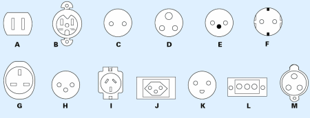
In the United States and Canada, type A sockets are used with 110 volts (see picture below). You need a travel plug converter (From Europe to America). Google on 'travel plug America' and you will find various offers immediately.
Time difference
In the US and Canada it's 7-8 hours earlier in the day than in Western Europe. While chasing we keep to Central Time, even if we're in the Mountain Time zone on the western fringes of Tornado Alley.
Clothing
We go to warm areas with temperatures during the day between 25 en 35 degrees. However, during storm chasing, tempereatures can drop to below 20 degrees and with strong winds this will feel very cold. So a sweater and rain coat (or windstopper) are essential to pack.
Phone & internet
We will install a WiFi hotspot in the car for your convenience, without any charge. We will ask you to turn off all automatic updates of apps and photos to cloud services. It is often possible to call via the internet, but here again we will ask you to turn off the video.
Flight schedule
We will fly into Denver International Airport. From there we can reach almost all locations in Tornado Alley for next day storm chasing. And with some luck, we could even chase the day of arrival.
We travel with reputable airlines such as KLM, AirFrance & Delta from SkyTeam.
Below are some examples of flights for May 2019. Airline companies can make changes to this. The time schedules mentioned are therefore indicative. Our actual flights can be with another airline and / or with another intermediate stop. Current pricing is around €500 - €600 for a return flight.
(example)
Amsterdam-Denver
3 May 2019: 10: 30-15:44 Delta via Minneapolis
13/14 May 2019: 18:00-13:25 Delta via Minneapolis


